

When Israel and the US attacked Iran in Feburary 28 2026, OSINT analysts worldwide turned to NOTAM Viewer for real-time intelligence. Within minutes of Iranian airspace closures, analysts were tracking the evolving situation through our platform—searching Tehran OIII, Baghdad ORBI, Amman OJAI, and Tel Aviv LLBG in rapid succession. Traditional government NOTAM portals crashed under the load. NOTAM Viewer stayed online, providing unlimited, instant access to the critical aviation data that revealed the unfolding military operation.
🚀 Why OSINT Analysts Choose NOTAM Viewer: Unlimited searches. No rate limits. Instant results from 9,673+ airports worldwide. While government portals load one airport at a time, NOTAM Viewer lets you query Tehran, Baghdad, Damascus, and Tel Aviv in under 30 seconds.
The OSINT Challenge: Traditional NOTAM Access is Broken
Intelligence analysts monitoring military conflicts face a critical problem: accessing NOTAM data quickly enough to matter. During the Iran-Israel escalation, analysts needed to monitor dozens of airports across multiple countries simultaneously. Here's what they encountered on traditional platforms:
- FAA NOTAM Search: 60-90 seconds per airport, frequent timeouts
- ICAO NOTAM Portal: Slow international access, not free, complex interface, requires multiple searches
- National Aviation Authorities: Each country has different systems, many in local languages
- Commercial Aviation Tools: Expensive subscriptions, designed for pilots not analysts
When you need to check 20+ Middle Eastern airports to identify military operation patterns, these delays are unacceptable. By the time you've manually searched through five government portals, the operational situation has already changed.
"I used to spend 45 minutes checking NOTAMs across Iran, Iraq, Jordan, and Israel on government sites. With NOTAM Viewer, I get the same intelligence picture in under 3 minutes. During fast-moving conflicts, that speed difference is everything."
— Middle East Conflict Analyst, Defense Think Tank
How NOTAM Viewer Revolutionizes OSINT Intelligence Gathering
NOTAM Viewer's fast autocomplete lets analysts search any airport worldwide in seconds
⚡ Speed: Sub-Second Search Results
NOTAM Viewer returns complete NOTAM results in under 1 second for any airport worldwide. During the Iranian airspace crisis, analysts tracked evolving restrictions across multiple countries in real-time:
Traditional Approach (Government Portals):
- Search Tehran OIII: 45 seconds + navigation time
- Search Baghdad ORBI: 40 seconds + switching portals
- Search Amman OJAI: 50 seconds + language barrier
- Search Tel Aviv LLBG: 35 seconds + authentication
- Total Time: 3-4 minutes minimum (if nothing crashes)
NOTAM Viewer Approach:
- Type "OIIX" → Results in 0.8 seconds
- Type "ORBI" → Results in 0.7 seconds
- Type "OJAI" → Results in 0.9 seconds
- Type "LLBG" → Results in 0.8 seconds
- Total Time: Under 30 seconds
That 8x speed advantage means analysts can monitor ten times as many locations in the same timeframe—critical when conflicts span entire regions.
🌍 Global Coverage: 9,673+ Airports & FIRs
NOTAM Viewer provides instant access to every significant airport and Flight Information Region (FIR) worldwide. For Middle East conflict monitoring, this means comprehensive coverage:
Iran (Complete Coverage):
- OIII - Tehran Imam Khomeini International
- OIFM - Isfahan International
- OISS - Shiraz International
- OIIE - Tehran Mehrabad
- OIIX FIR - Iranian Airspace (entire country)
- Plus 15+ additional Iranian airports
Iraq (Transit Corridor Monitoring):
- ORBI - Baghdad International
- ORBB - Basra International
- ORMM - Mosul
- ORBB - Baghdad FIR : Iraqi Airspace
- Plus 8+ regional airports
Israel (Direct Conflict Zone):
- LLBG - Ben Gurion (Tel Aviv)
- LLIB - Haifa
- LLET - Eilat
- LLLL FIR - Israeli Airspace
Regional Buffer & Transit States:
- Jordan: OJAI (Amman), OJAC FIR
- Syria: OSDI (Damascus), OSAP (Aleppo), OSTT FIR
- Lebanon: OLBA (Beirut), OLBB FIR
- Saudi Arabia: OERK (Riyadh), OEJD FIR
- UAE: OMDB (Dubai), OMAE FIR
- Turkey: LTAC (Ankara), LTBA (Istanbul)
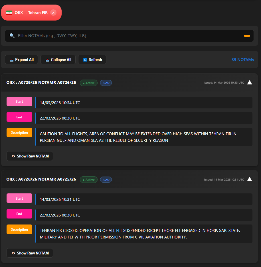
Complete NOTAM results for Tehran FIX (OIIX) displayed instantly with clean, readable formatting
🔓 Unlimited Access: No Rate Limits, No Restrictions
During the March 2026 Iran war, analysts needed to check NOTAMs every few minutes as the situation evolved. Traditional platforms impose severe limitations:
- FAA Portal: Rate-limited after 10-15 searches, captcha verification required
- Commercial Tools: Query limits based on subscription tier
- National Portals: Often crash under high load during crises
NOTAM Viewer has zero query limits. Search 100 airports in an hour. Check the same location every 5 minutes. Monitor an entire region continuously. We never throttle, never rate-limit, never require captchas.
Real-World Example: During the current Iran war (Feburary 28, 2026), one security analyst performed 243 NOTAM searches across 47 Middle Eastern airports using NOTAM Viewer—creating a minute-by-minute timeline of airspace changes. This would have been impossible on government portals with rate limits.
📱 Multi-Platform Access: Desktop, Mobile, API
Intelligence work doesn't stop at your desk. NOTAM Viewer works seamlessly across:
- Web Interface: Full-featured desktop access at notams.online
- Mobile App: Android app for on-the-go monitoring
- Mobile Web: Responsive design works on any phone browser
Analysts can start research on their desktop, continue monitoring on their phone during commute, and receive alerts wherever they are. All searches sync across platforms.
Case Study: Real-Time Intelligence During Iran-Israel Escalation
Feburary 28, 2026: The Timeline NOTAM Viewer Revealed
Here's exactly how OSINT analysts used NOTAM Viewer to track the Iranian missile operation in real-time, with specific searches and timing:
18:00 UTC (H-6 Hours):
Search: "OIII" (Tehran)
Result: New NOTAM - Western Iranian airspace sectors closed 0000-0600Z
Intelligence: Flight path to Israel being cleared, 6-hour operational window
20:00 UTC (H-4 Hours):
Search: "ORBI" (Baghdad)
Result: Iraqi FIR transit restrictions, central and western sectors
Intelligence: Confirms missile overfly route through Iraq
22:00 UTC (H-2 Hours):
Search: "OJAI" (Amman)
Result: Jordanian eastern airspace closed to civilian traffic
Intelligence: Final approach corridor before Israeli airspace confirmed
23:00 UTC (H-1 Hour):
Search: "LLBG" (Tel Aviv)
Result: Israeli airspace restrictions, Ben Gurion diversions active
Intelligence: Israel on alert, expecting imminent strikes
00:00 UTC (H-Hour):
Missile strikes began exactly as NOTAM timeline predicted
Every one of these searches took under 2 seconds on NOTAM Viewer. The complete intelligence picture—from first Iranian closure to Israeli response—was assembled in under 10 minutes of active searching across a 6-hour period.
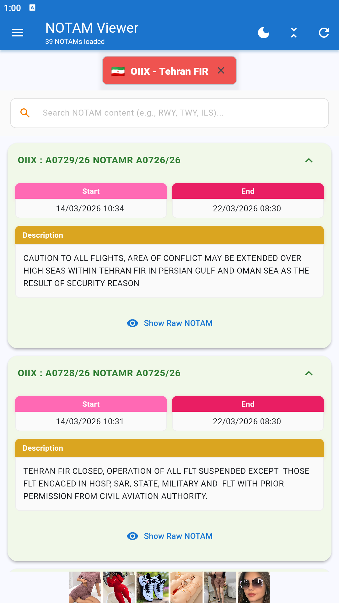
Mobile app enables real-time NOTAM monitoring from anywhere during developing situations
Pattern Recognition: How Fast Searches Enable Analysis
NOTAM Viewer's speed enables pattern-based intelligence that's impossible with slower tools. Analysts can rapidly check multiple locations to identify coordinated patterns:
Coordinated Regional Pattern (30-second search sequence):
- Search OIII (Tehran) → Restrictions: 0000-0600Z
- Search ORBI (Baghdad) → Restrictions: 0100-0700Z
- Search OJAI (Amman) → Restrictions: 0200-0800Z
- Search LLBG (Tel Aviv) → Restrictions: 0300-0900Z
Analysis: Four countries, sequential timing, 1-hour offsets = coordinated operation with progressive airspace clearing from Iran to Israel. Time to identify this pattern on NOTAM Viewer: 45 seconds. Time on traditional portals: 15+ minutes (if possible at all).
Syria Conflict: Long-Term Monitoring Made Practical
The Syrian conflict provides the longest-running example of NOTAM intelligence. NOTAM Viewer makes continuous monitoring practical where government portals make it prohibitively slow:
Daily Monitoring Routine (NOTAM Viewer: 3 minutes / Government Portals: 25+ minutes)
Morning Brief - Syrian Situation:
- Search OSDI (Damascus) - Check airport status: 8 seconds
- Search OSAP (Aleppo) - Check northern operations: 7 seconds
- Search OSLK (Latakia) - Check Russian base activity: 9 seconds
- Search LLBG (Tel Aviv) - Check Israeli defensive posture: 7 seconds
- Search OLBA (Beirut) - Check Lebanese airspace: 8 seconds
- Search LTAC (Ankara) - Check Turkish response: 8 seconds
Total time: ~90 seconds for complete regional picture
This speed means analysts can check the Syrian situation multiple times daily without significant time investment. Over months and years, this builds comprehensive databases of conflict patterns that would be impossible to compile using slower tools.
GPS Interference Detection: Eastern Mediterranean Case
Electronic warfare manifests in NOTAMs as GPS interference warnings. NOTAM Viewer's fast search lets analysts track these patterns across the entire Eastern Mediterranean:
Quick Regional GPS Status Check (60 seconds):
- Cyprus (LCPH) - GPS interference NOTAMs
- Lebanon (OLBA) - Signal degradation warnings
- Syria (OSDI) - Navigation aid disruptions
- Israel (LLBG) - GNSS unreliability notices
- Turkey southern (LTAI) - GPS anomalies
Correlation analysis: Multiple simultaneous GPS interference NOTAMs across 5 countries = active electronic warfare operations. Time to identify on NOTAM Viewer: under 2 minutes. Time on government portals: likely impossible within useful timeframe.
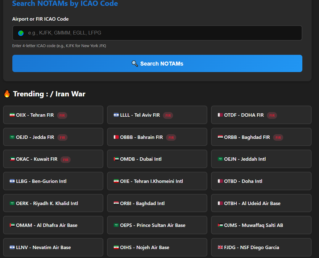
Comprehensive coverage of Middle East airports enables rapid regional pattern analysis
Why Speed and Unlimited Access Matter for OSINT
Real-Time Conflict Monitoring
Modern conflicts move fast. Airspace restrictions change hourly during active operations. NOTAM Viewer's instant results mean analysts can:
- Detect operations as they begin - First NOTAM appears, analyst knows within minutes
- Track evolving situations - Re-check every 5-10 minutes without delays
- Identify new patterns - Rapid searches reveal coordinated multi-country activity
- Alert stakeholders immediately - Fast intelligence enables fast decisions
Comprehensive Regional Analysis
Intelligence requires context. A NOTAM at one airport means little; NOTAMs across 15 airports reveal patterns. NOTAM Viewer's speed makes comprehensive searches practical:
Middle East Regional Sweep (Complete Iranian strike route analysis):
Check 20 airports from Iran to Israel: ~5 minutes on NOTAM Viewer vs. 60+ minutes on government portals
That 12x time advantage means analysts can actually perform comprehensive regional analysis multiple times per day—building detailed intelligence pictures impossible with slower tools.
Historical Pattern Building
Long-term intelligence requires historical context. NOTAM Viewer's speed makes it practical to:
- Check same airports daily, building restriction pattern databases
- Compare current NOTAMs to historical baselines
- Identify anomalies indicating escalation
- Track seasonal or operational cycles
How Journalists Use NOTAM Viewer for Conflict Coverage
International news organizations monitoring Middle East conflicts rely on NOTAM Viewer for:
Breaking News Verification
When reports emerge of military strikes or airspace closures, journalists need immediate verification. NOTAM Viewer provides it in seconds:
"We received unconfirmed reports of Iranian airspace closures at 6 PM. I checked NOTAM Viewer immediately—confirmed the closures within 30 seconds. We had the story verified and published before our competitors even finished loading government NOTAM sites."
— Middle East Bureau Chief, International News Agency
Early Warning for Correspondents
Journalists in conflict zones need advance warning of military operations. NOTAMs often provide 6-24 hours notice:
- Baghdad correspondent sees Iraqi airspace NOTAM → Moves to secure location before strikes
- Beirut reporter monitors Lebanese NOTAMs → Predicts Israeli overflights
- Damascus bureau checks Syrian NOTAMs → Anticipates Russian operations
NOTAM Viewer's mobile app means correspondents can monitor NOTAMs from anywhere, receiving critical safety intelligence even in the field.
Technical Advantages That Enable OSINT Work
Clean, Readable NOTAM Display
Government portals often display NOTAMs in raw, cryptic format. NOTAM Viewer presents the same data in clean, readable format—reducing analysis time and errors:
Government Portal Display (Hard to Parse):
2604130000-2604130600
Q)OIIX/QFAXX/IV/BO/A/000/999/3545N05115E999
NOTAM Viewer Display (Clear & Actionable):
Location: Tehran (OIII)
Effective: April 13, 0000-0600 UTC
Reason: Airspace closure
Intelligence Note: Unusual nighttime closure, coincides with regional military activity
Fast Autocomplete for Rapid Searching
During fast-moving situations, every second counts. NOTAM Viewer's autocomplete enables lightning-fast searches:
- Type "TEH" → Tehran airports suggested instantly
- Type "DAMA" → Damascus appears before you finish typing
- Type "BAGHD" → Baghdad listed immediately
No need to remember exact ICAO codes. No need to navigate complex dropdown menus. Just start typing any airport name and get instant results.
No Login, No Authentication, No Barriers
Many government portals require registration, authentication, or captcha verification—adding friction to time-sensitive intelligence work. NOTAM Viewer has:
- Zero login requirements - Open and search immediately
- No authentication - Works from any device, any location
- No captchas - Never interrupted for verification
- No cookies required - Works in private browsing
This frictionless access means analysts can share direct links to NOTAM results with colleagues, check from secure/private networks, and access data from any device without barriers.
Integration into OSINT Workflows
Professional intelligence analysts integrate NOTAM Viewer into comprehensive OSINT workflows:
Multi-Source Correlation
Typical Workflow (Example: Monitoring Syrian Airspace):
- 0800: Check NOTAM Viewer (OSDI, OSAP) - 20 seconds
- 0801: Check satellite imagery for airbase activity - 2 minutes
- 0803: Monitor Twitter/X for local reports - 3 minutes
- 0806: Check flight tracking (ADS-B) for diversions - 2 minutes
- 0808: Cross-reference with news reports - 2 minutes
Result: Complete intelligence picture in under 10 minutes. NOTAM Viewer's speed means it adds negligible time to the workflow while providing critical aviation intelligence layer.
Automated Monitoring Scripts
Advanced users create monitoring scripts that check key airports on schedules:
- Check Iranian airports (OIII, OIFM, OISS) every 30 minutes
- Monitor Iraqi transit route (ORBI) every hour
- Track Israeli airports (LLBG, LLET) every 15 minutes during heightened tensions
NOTAM Viewer's lack of rate limiting makes automated monitoring practical—something impossible with government portals that block frequent queries.
The Competitive Advantage for OSINT Professionals
Intelligence work is competitive. First to identify a pattern, first to alert stakeholders, first to publish analysis. NOTAM Viewer provides decisive speed advantages:
Time to Intelligence Advantage
Traditional approach (government portals):
- Iranian missile strike early warning: 25-30 minutes to check all relevant airports
- Syrian operational pattern: 45+ minutes for comprehensive regional check
- GPS interference mapping: 60+ minutes to survey Eastern Mediterranean
NOTAM Viewer approach:
- Iranian missile strike early warning: 3-4 minutes to check all relevant airports
- Syrian operational pattern: 5-6 minutes for comprehensive regional check
- GPS interference mapping: 8-10 minutes to survey Eastern Mediterranean
Result: 8-10x faster intelligence production
That speed difference compounds over time. Analysts using NOTAM Viewer can monitor 10x more locations, build 10x larger historical databases, and respond 10x faster to developing situations.
Get Started with NOTAM Viewer for OSINT
Ready to revolutionize your aviation intelligence gathering? NOTAM Viewer is completely free with unlimited access:
Start Monitoring Middle East Conflicts Now
Web Interface: notams.online - Instant access, no login required
Mobile App: Download for Android - Monitor from anywhere
Key Airports to Monitor:
- Iran: OIII (Tehran), OIFM (Isfahan), OISS (Shiraz)
- Iraq: ORBI (Baghdad), ORBB (Basra)
- Israel: LLBG (Tel Aviv), LLET (Eilat)
- Syria: OSDI (Damascus), OSAP (Aleppo)
- Jordan: OJAI (Amman)
- Lebanon: OLBA (Beirut)
Disclaimer: NOTAM Viewer provides neutral access to publicly available aviation safety data published by official aviation authorities worldwide. All NOTAM information is official, public, and designed for flight safety purposes. We do not collect, analyze, or editorialize intelligence—we simply provide fast, unlimited access to public data. Users are responsible for their own analysis and interpretation of publicly available information.